
If you have an iterative ecological forecast project that you’d like added to this list, you can create a profile for the project using this form.
| Project | Description |
|---|---|
| Temperatures higher than 42°C (107.6°F) can kill flying-foxes ('fruit bats'; Pteropus spp.) at sometimes biblical scales. To aid wildlife rehabilitators, land managers, and other stakeholders in coping with such events, the Lab of Animal Ecology team from Western Sydney University and the University of Melbourne has developed a Flying-Fox Heat Stress Forecaster. The Forecaster predicts the roost locations where flying-foxes are likely to experience extreme heat, up to 72 hours into the future. | |
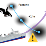
| The Southern Resident Killer Whales are an endangered population of cetaceans living in the Salish Sea. In this area, the marine traffic is intense and is expected to grow in the future. To mitigate the risk of acoustic disturbance and collision with commercial vessels, we developed a statistical framework for a real-time data assimilative forecasting system. The model predicts in real-time the current and future locations of SRKW using a state space model and an iterative data assimilation method. We used real-time observations (visual sightings and passive acoustic monitoring), preferred habitat, and static environmental data (bathymetry and coastline) to correct the predictions. See details about the forecast, the paper describing it, and a Shiny app HERE. | |
| Invasive pests present a significant threat to agricultural production in the United States, yet decision support tools that can accurately predict where and when to expect pests have not yet been fully developed and utilized. The spatial modeling platform known as DDRP (Degree-Days, Risk, and Phenological event mapping) was designed to provide regularly updated forecasts of the potential distribution (risk of establishment) and timing of seasonal activities (phenology) of pests. | |
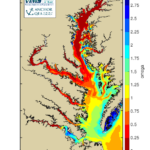
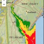
| The Chesapeake Bay Environmental Forecasting System (CBEFS) developed by scientists at VIMS produces short-term forecasts of hypoxia, acidification, and harmful algal blooms for the Bay, and an annual hypoxia report card to track progress towards attaining water quality standards. Through CBEFS ongoing collaborative work with Chesapeake Bay Program managers as well as fisheries and aquaculture industry members, they continue to work to make their science highly relevant and useful for Chesapeake Bay stakeholders. | |
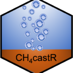
| CH4castR is a methane ebullition forecast that developed weekly forecasts of CH4 ebullition from a freshwater drinking reservoir in Southwest Virginia, USA. | |
| The Ecosystem Monitoring for Management Application (EMMA) project is developing an operational system and tools for monitoring the vegetation state of the Cape Floristic Region of South Africa, a fire-prone shrubland ecosystem. EMMA combines Earth observations, in situ observations, and ecological forecasting models to characterize the spatial and temporal variation of the vegetation state for near real-time monitoring and change detection in the study region. | |
| Ecocaster is a forecasting system built on community- and crowd-sourced data. Projects range from jellyfish forecasts to real-time predictions of moose-car-interaction risk. | |
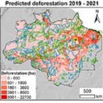
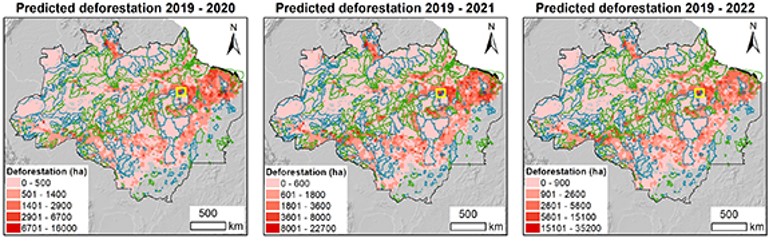
| Forecasting Deforestation in the Brazilian Amazon to Prioritize Conservation Effortst coupled high-resolution land-cover maps with Bayesian hierarchical spatial models to identify the main drivers of recent deforestation in the Brazilian Amazon and predicts which areas are likely to lose a larger proportion of forest in the next 3 years. | |
| The Early Warning and Forecasting System for Biodiversity on the California Coast is building the capacity to translate the hundreds of thousands of biodiversity observations contributed by the community on the California coast and crowdsourced via iNaturalist into indicators of biodiversity change useful for research and management. | |
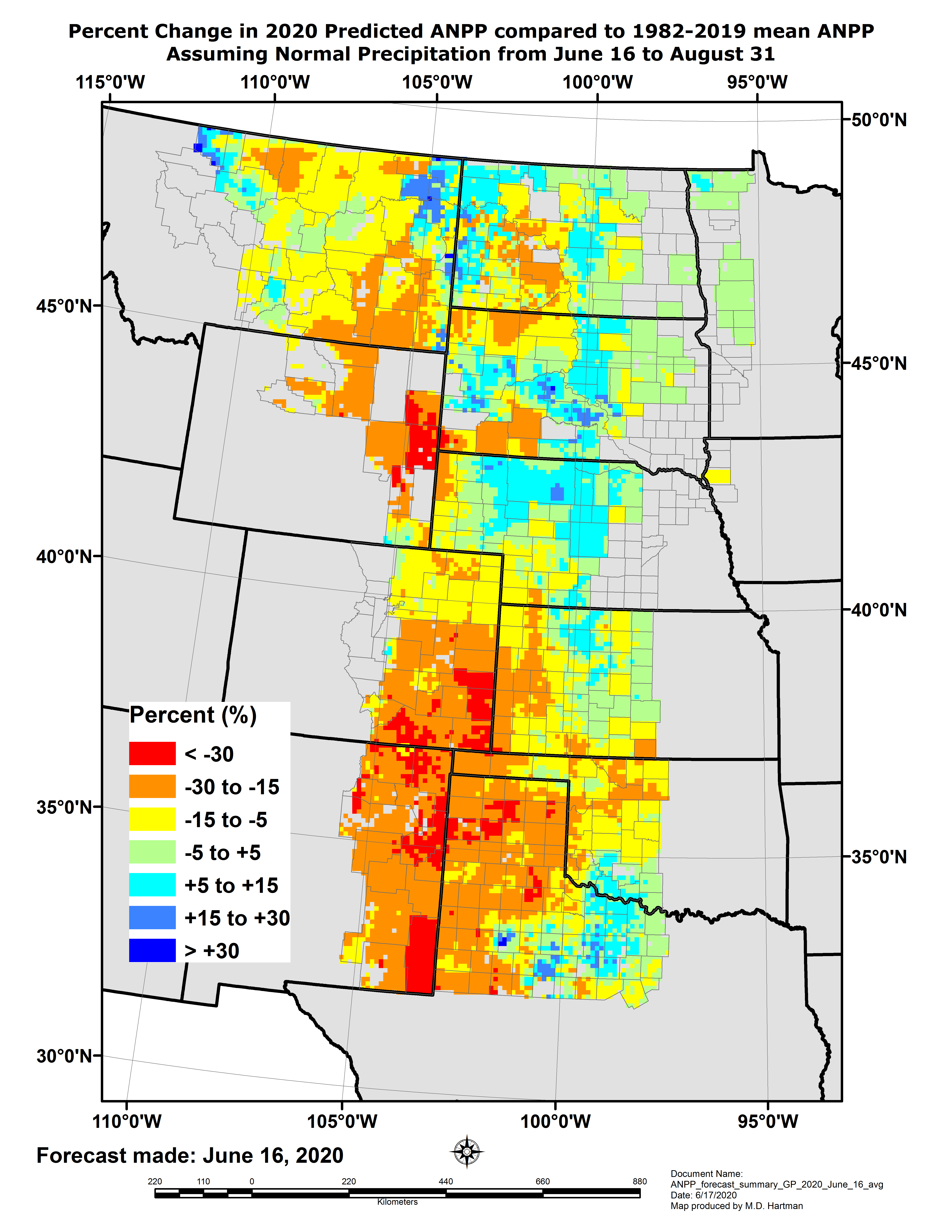
| Grass-Cast is a grassland productivity forecast system for the U.S. Great Plains and for the Southwest U.S. (New Mexico and Arizona). Grass-Cast uses well-known relationships between historical weather and grassland production. It combines satellite-derived NDVI, recent weather data, and seasonal climate outlooks (from NOAA Climate Prediction Center) with a well-trusted grassland model (DayCent) to predict growing season grassland productivity (lbs/acre) at a 10 km x 10 km resolution, compared to each area’s long-term average. | |
| Joe Bennett's lab from Carleton College uses predictive models of bird population trends to help locate areas for conservation. They also work to harmonize predictions among datasets. | |
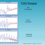
| Boston University's Jim Stodder is working with Structured Vector Auto-Regression (SVAR) forecasts of Carbon Tax. SVARs are much used in Finance, but underused in ecoforecasting. They have a better track record for short-run forecasts. | |
| The USA-NPN Pheno Forecast delivers short-term (6d) threshold-based forecasts of phenological events in plants and pest insects. We are working on more sophisticated approaches for additional events. | |
| The Coastal Carbon Research Coordination Network (CCRCN) seeks to accelerate science of coastal wetlands. Our Soil Carbon working group is developing spatially-explicit predictions of carbon stocks and sequestration rates, and seeks to determine how variation in carbon stocks and burial rates is attributable to field and lab techniques vs. process uncertainty. | |
| The Jefferson Project at Lake George seeks to fuse sensor observations, experiments, and modeling to create a new model for environmental monitoring and prediction. Near-term forecasts link weather models, terrestrial ecosystem and run off models, and lake hydrodynamic and ecosystem models to understand and predict short-term variations in water resources. | |
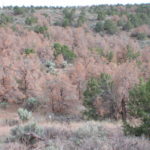 Chasing Tree Die-off | The Chasing Tree Die-off project expands near-term ecological forecasting by incorporating short-term local experiments and regional surveys during developing extreme climatic events for pinyon-juniper woodlands in the Southwest. |
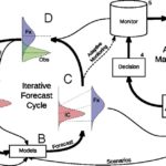
| Researchers at Boston University and the Cary Institute are working to develop an iterative cycle between making forecasts, performing analyses, and updating predictions in light of new evidence. | |
| The "Smart & Connected Water Systems" project is developing a smart water system that integrates novel high-frequency sensors, cyberinfrastructure, and ecosystem forecasting techniques to improve the management of drinking water supply lakes and reservoirs | |
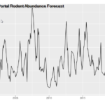
| Ecologists at the University of Florida are forecasting ecological systems from time series, specifically rodent abundances from The Portal project located in the Chihuahuan desert of southern Arizona. Iterative near-term forecasts of rodent abundances are developed then tested as new data is collected on an approximate monthly time-scale. | |
| MAPPPD (Mapping Application for Penguin Populations and Projected Dynamics) is an open access decision support tool designed for managers, scientists and the general public. This integrates advanced modeling techniques to detect and count penguin colonies from remote sensing data. MAPPPD also calculates occupancy probabilities and presents graphical output which projects how penguin populations will change in the future. The MAPPPD team recently ran a forecasting data science competition; more details HERE. | |
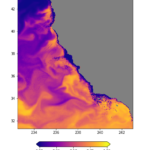
| The CA HAB Bulletin, developed by the Southern California Ocean Observing System (SCCOOS), provides monthly to bi-monthly context for the C-HARM model output relative to harmful algal bloom observations and available marine mammal stranding data. C-HARM creates daily nowcasts and 3-day forecasts of harmful algal bloom (Pseudo-nitzschia spp.) and phycotoxin (domoic acid) risk for coastal California (domain out to 1000 km) | |
| EcoCast is a fisheries sustainability tool that helps fishers and managers evaluate how to allocate fishing effort to optimize the sustainable harvest of target fish while minimizing bycatch of protected or threatened animals. | |
| The Atlantic Sturgeon Risk of Encounter forecast is developed for mature Atlantic Sturgeon using historic telemetry observations matched to date, bathymetry, and sea surface temperature and ocean color from NASA’s MODIS AQUA satellite. | |
| PROGNOS is developing an integrated approach that couples high frequency (HF) lake monitoring data to dynamic water quality models to forecast short-term changes in water quality (e.g. DOM pulses and algal blooms). | |
| WATExR aims to integrate state-of-the-art climate seasonal prediction and water quality simulation in a QGIS-based advanced solution to ensure efficient decision making and adaptation of water resources management to an increased frequency of climate extreme events | |
| The PalEON project improves long-term forecasts of terrestrial ecosystem response to changing climate, land-use, and natural disturbance by assimilating information from historical and paleoecological data into a suite of models. | |
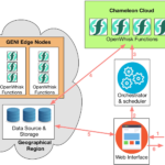
| Boston University's Abraham Matta and Mike Dietze are building a hybrid elastic edge-cloud infrastructure to support repeatable ecological research through the A Scalable and Secure Cyberinfrastructure for the Repeatability of Ecological Research project. |


